
Description
mount riham ascent

View Point

Greenery

Trekking

Heights

Water Feature
Intermediate
-
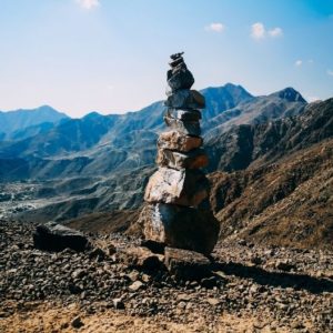
A relatively new trek established by Fujairah Adventures, the ascent follows the natural inclines of Saham’s cascading mountains. The trek is an alternative to the wadi canyon trail that descends into al Hayl. A large petroglyph stands watch at the beginning of the trek as a reminder of the historical importance that these mountains and villages hold.
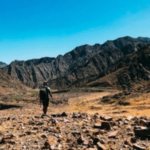
The trail is an unforgiving one, with steep grades off the bat. Less than an hour in, you will find a beautiful view of the road and valley below. Continuing the climb, you will reach your first ascent, with a flag marking a stunning viewpoint of the village below. The final summit up is still quite a workout, but the reward at the top is worth it. Here, you will see a panoramic viewpoint of mainland Fujairah, the ocean, and the villages of Al Hayl and Saham. The final descent down will find a much rougher gully (canyon drainage) going down, marked with vegetation and traces of perennial springs.
The petroglyphs in the area have to a large extent been preserved by a natural bacterial deposit, known as desert varnish. Similar petroglyphs have also been found in the nearby sites of Wadi Hayl, Hassat Al Risoom (literally ‘Rock with Drawings’) close to the village of Roweida, and Wadi Al Shanah, dating to between 1300 and 300 BCE (some as early as the “Bronze Age”).
Upcoming dates
| DATE | TIME | ADULT | CHILD |
|---|---|---|---|
| Sunday, April 7, 2024 | 7:00 AM Meet-up | AED 220 | AED 150 |
| Sunday, May 26, 2024 | 6:00 AM Meet-up | AED 220 | AED 150 |
Trip Details
Schedule
7:00 AM: Meet at the ADNOC (Mainland Fujairah) and convoy to the trailhead
7:45 AM: Begin the hike
10:45 AM – 11:45 AM: Complete hike
What’s Included
— Experienced and certified mountain guide (English speaking)
— Outdoor education, Assistant Guide/s
— First Aid
What to Bring
— 1-2 liters of water (December – March) | 2-3 liters of water (for the rest of the months)
— backpack
— salted snacks and/or fruit for a few hours of hiking with a little extra — in case of delay
— hiking boots or trainers with good grip/not worn out
— shorts or comfortable hiking pants/leggings
— t-shirt light pullover for sun protection/warmth in the morning/evening
— hat
— sunscreen
— sunglasses
— trekking poles (optional to help with balance or mitigate fatigue)
Trail Info
Trail Type: Loop
Distance: 7.5 KM
Elevation Gain: 470 M
Trail Time: 3 – 4 hours
Difficulty level
Intermediate (6/10)
(steady ascent and descent, loose rocks, exposure to heights, sun exposure, potential hazardous species)
[Beginners add 2, Experienced subtract 2 to difficulty]
*Not recommended for individuals who are not-active, heavily smoke, have vertigo or fear of heights