
Description
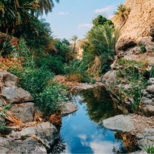
Wadi Isfay

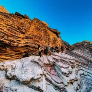
View Point

Wildlife

Trekking

Heights
Intermediate+
Wadi Isfay, Ras al Khaimah
Welcome to Wadi Isfay, and it’s neighboring village, Wadi Isfini!
Officially located in southern Ras Al Khaimah, the area extends from the village of Sifuni close to Mleiha, bordering the Fujairah highway (E84), and joined through to Wadi Shawkah. With high levels of winter rainfall, the valleys transform with the blooming of regional vegetation, sculpted by the flash floods of nature’s raw power. The area boasts a unique combination of water sources, mountainous terrain, verdant trees, and wild herbs, creating a picturesque setting that captivates both locals and visitors alike.
Wadi Isfini, derived from “Al-Safi” meaning flat stones on the ground, is a living testament to the region’s cultural and educational richness. The Mazari tribe, the traditional inhabitants of Wadi Isfai, who have thrived in this rugged terrain for generations. The wadi is not only a living testament to their heritage but also a sanctuary for biodiversity, with the discovery of the Meharia breithaupti moth, adding a touch of scientific significance to its rich tapestry. Residents relied on cultivating palm trees, wheat, corn, and livestock. The region was once teeming with wild animals, a reflection of its unspoiled beauty.
Trail Info
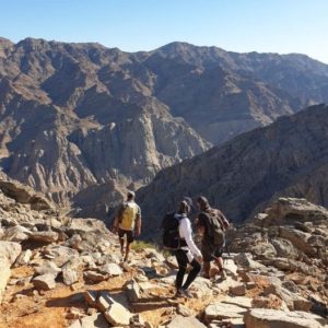
The trail enters at the end of the local neighborhood, and follows the wadi towards the regional dam. The further in you get, the greater the elevation becomes, until you look back and see the “grand valley” below, reminding you why this trail is Intermediate+ to Advanced.
Not being a set commercial trail, we follow game trails and natural gradients along the mountain to reach the top, where an off road has been built by the local inhabitants who have place their home upon the mountain. We then follow the ridge line back, with a mix of scrambling, sitting and hiking at greater loss of elevation from the way up. Be careful! This trail is short but it is non-the-less wild and is meant for those looking for the challenge!
Upcoming dates
| DATE | TIME | PARTICIPANT |
|---|---|---|
| Saturday, February 10, 2024 | 6:00 AM Meet-up | AED 220 |
| Thursday, March 7, 2024 | 6:00 AM Meet-up | AED 150 |
Trip Details
Schedule
6:00 AM: Meet at the ADNOC| Taybah (656) Mleiha Sharjah gas station
7:00 AM: Convoy to Wadi Isfay, park, begin the trek
11:00 AM – 12:00 PM: Finish Hike
What’s Included
— Experienced and certified mountain guide (English speaking)
— Natural and cultural history education
— Outdoor education, Assistant Guide/s
— First Aid
What to Bring
— 1-2 liters of water (December – March) | 2-3 liters of water (for the rest of the months)
— backpack
— salted snacks and/or fruit for a few hours of hiking with a little extra — in case of delay
— hiking boots or trainers with good grip/not worn out
— shorts or comfortable hiking pants/leggings
— t-shirt light pullover for sun protection/warmth in the morning/evening
— hat
— sunscreen
— sunglasses
— trekking poles (optional to help with balance or mitigate fatigue)
Trail Info
Trail Type: Loop
Distance: 7.76 KM
Elevation Gain: 514 M
Trail Time: 4-5 hours
Difficulty level
Difficulty: Intermediate+ (7/10)
(steep ascent, slippery areas, length of the trail, sun exposure, loose rocks, hazardous species, unmarked trail, slight bouldering)
[Beginners add 2, Experienced hikers subtract 2 to difficulty]
Not recommended for individuals who are not active, smoke heavily, have vertigo or fear of heights